![]()
Oxford University, Trinity Term 2005
Reuters Foundation Fellowship
Research Paper (Summary)
Rainer Hoerig
Acknowledgement: The author is grateful to the Reuters Foundation, London for making this study possible.
India is heading for a major water crisis. Devastating floods and droughts, dangerous pollution levels in most rivers and lakes, controversial dam projects and over-exploitation of ground water resources are its main indicators. One of the responses by the government is a programme to interlink major rivers with the help of large reservoirs and broad canals in order to enable a transfer of water from „surplus“ to „deficient“ regions. Rainer Hoerig’s paper explains the main features of this project. The author looks at existing river diversion projects in India and analyses their performance. The paper sums up scientific evidence and experience with river diversions in other countries around the globe. Based on this information an attempt is made to assess social and environmental consequences of the programme of interlinking India’s rivers.
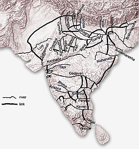
The programme of interlinking rivers envisions the creation of 31 links, each one encompassing at least one reservoir on each of the rivers and large canals to connect them. A Northern grid is to be formed by linking most sub-Himalayan rivers in the Ganga and the Brahmaputra basins. A Sourthern Grid shall comprise of all major peninsular rivers linked through canals at different elevations. The overall cost of the project is calculated to be 5,600 billion Indian rupees, approximately 125 billion US dollars . The programme is promoted to put an end to the occurrence of floods and droughts and create a huge employment potential in rural areas. It is projected to add 35 million hectares to India's irrigated farmlands and generate 34,000 MW of hydropower.
India is the third largest dam builder in the world. Most of the 4,291 large dams constructed so far have been designed as multipurpose projects for irrigation and hydropower generation. A few of them serve to divert large amounts of a river's flow into another basin, similar to what the programme of interlinking rivers envisions. Between the Southern States of Kerala and Tamil Nadu several west-flowing rivers were diverted to the East to enable farmland irrigation in the dry interiors of Tamil Nadu. Though this scheme has opened up new areas for agriculture in Tamil Nadu, in Kerala it has acerbated recent droughts and is now resented by many local farmers.
The 445 km long Rajasthan Canal has brought water from the Himalayas into the Thar desert. It has greened many a landscape but also brought malaria to the villages in the desert. Recent droughts have exposed the dependency of desert farmers on the water bureaucracy. During protests several farmers were shot dead by police.
Since India completed the Farakka-Barrage on river Ganga in 1974, a few kilometres before it enters Bangla Desh, relations between the two neighbours have been strained. India maintains the barrage to be necessary to keep the port of Kolkata running, while Bangal Desh complains about being deprived of badly needed water for her agriculture. The Bangla Desh government has already indicated its strong opposition to the programme of linking rivers.
A series of large dams to be built on the Narmada river in central India has evoked strong protests from local farmers and indigenous people fearing displacement into poverty. Their struggle has fuelled public debates about the gains and losses of large dam projects. It has also exposed the inability of the government machinery to successfully rehabilitate those millions of people whose lands and houses were sunk in reservoirs.
Canada is called the world leader in inter-basin transfers. Mainly in the western parts of the country 59 large diversions were constructed. But after scientific studies exposed increased channel and shore erosion in "topped-up" rivers and lakes as well as high sedimentation and a deterioration in the water quality in reservoirs the erstwhile enthusiasm about river diversions has dampened in the country.
In the 1950s and 1960s planners in the erstwhile Soviet Union diverted two mighty rivers of central Asia to turn large semi-desert areas into cotton fields and fruit orchards. Today the Amu Dar'ya and the Syr Dar'ya fall dry in their lower stretches and deprive the Aral Sea of water. The world's fourth largest freshwater lake has shrunk to a quarter of its original size. Tens of thousands of fishers have lost their income. Dust storms rake up salt and toxic residues of pesticides. Those local inhabitants who did not flee the area suffer from high rates of throat, stomach and kidney cancer.
Colorado river is one of the most dammed rivers on the American continent. Its waters enable farmers in California to grow fruits and vegetables, they drench the thirst of mega-cities like Las Vegas and Los Angeles. But the delta of the mighty Colorado in the Gulf of California is virtually dry with all the river's water used up. Protests from environmental organisations have led to efforts to recreate natural river flows to a certain extend.
During the 1960's Egypt tried to tame the Nile river through the Aswan High dam. It helped to turn large desert tracks into farmland. But the fertilisation through Nile floods stopped. Today Egypt uses a good part of the electricity generated by the Aswan dam to produce mineral fertilisers. Due to less river flow the Nile delta, which comprises two thirds of Egypt's farmland, is in severe danger from erosion and salinization. Egypt was forced to spend about 2 billion US dollars on a drainage network to counter salt deposition, more than the original cost of the Aswan High dam.
In June 2001 the Spanish government adopted the Spanish National Hydroelectric Plan (NHP) plan, involving the construction of 120 new dams to enable transfers from the Ebro river to the south-east of Spain and from the Rhone river to Barcelona. Environmental and other NGOs, as well as numerous academics, scientists, unions and political parties objected to this project and staged public rallies. After scientific studies exposed grave environmental dangers, especially for the biologically rich delta of the Ebro, the Spanish government was forced to abandon the NHP in 2004.
Linking all major rivers in the Indian subcontinent poses a steep engineering and environmental challenge. If indeed only "surplus" water is to be diverted, huge reservoirs would be required. It is common knowledge that during the monsoon season all rivers of South Asia are in spate and any intake of more water would lead to large floods. To store 178 cubic kilometres of water, as planned, it would require nearly 59 Sardar-Sarovar-sized dam reservoirs. Critics raise the question how large amounts of water shall be transferred between different river basins which are usually divided by mountain ranges. Many question whether the country can afford to commit 125 billion dollars, nearly a fifth of the country's current GNP for one project. But the most serious of its consequences would be the large scale submergence of precious farmland and natural forests and the displacement of rural people. Promoters of the programme of river-linking have so far failed to publish any figures in this respect. On the basis of data from the World Bank, the World Commission on Dams and the International Water Management Institute it is calculated that the project of linking rivers will submerge between 12,500 and 21,000 square kilometers of forest and agricultural land and would displace between 2,755,000 and 4,187,000 persons. As experiences with many large dam projects in India show, the rehabilitation of such a large number of people is next to impossible under Indian circumstances.
The large-scale diversion of river waters alters the river ecology as examples from India and other countries have shown. Changes in water chemistry, in sedimentation patterns, in flow regimes can seriously harm the river’s ability to purify itself. Thus the role of rivers in sustaining life of flora, fauna and human populations will be put at risk and can lead to the extinction of species of fish and birds.
Conflicts about water resources in India are on the rise. Southern states Tamil Nadu and Karnataka are since decades locked in a fight about the use of water in river Cauvery. Water riots have cost hundreds of lives in India so far. The linking of rivers would create many more water wars and would seriously disturb relations with neighbours Nepal and Bangla Desh.
Water management experts and ecological scientist increasingly question the notion of "surplus" water by hinting at valuable ecological functions of floods that benefit riparian vegetation and fish populations. Latest research emphasizes that rivers are not mere channels through which water flows but complex ecological systems in which life-cycles of many different species are intertwined. The fate of the Aral Sea stands as a stark reminder that water flowing in rivers indeed has a purpose and is not „wasted“ if not used for irrigation or generation of hydropower.
Finally questions about the sustainability of large water diversions are raised. Man-made large dams usually have a lifespan of fifty to one hundred years, depending on the quality of construction and the rate of siltation in the reservoir. It is relatively easy to execute large infrastructure projects but can natural habitats, whose ecological balance has evolved through thousands, even millions of years, ever be restored? How will huge reservoirs and canals silted up with mud be decomissioned? Given the multiple risks and dangers of the programme to interlink rivers, it would be worthwhile to consider alternative solutions.